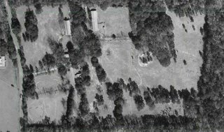
 Here is an older aerial view of the upper 30 acres of the farm. The curving line on the left side is the county road along our frontage. The two large buildings at the top are our barns. The planned house site is about a third of the way from the bottom straight south of the larger barn.
Here is a large view of the house site with a "cut out" of the current plan placed on it. I've angled the house slightly off straight north south the take better advantage of the views and the slope of the site. The red lines are the topo lines - heavy are every twn feet, light ones visible if you zoom in are every two feet.
The drive to the house site will come through a gap in the trees just north of the porte chochere. We'll have a turn around on that side of the house which will provide guest parking. Although the front porch is on the north, the approach will be from the west side.
No comments:
Post a Comment